The accurate measurement of Longitude
by Pete London
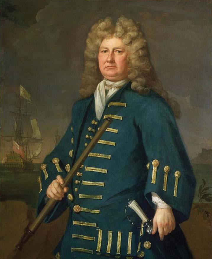
Sir Cloudesley Shovell was Commander of the British fleets during the reign of Queen Anne, a national hero who’d fought and defeated the Dutch, French and Spanish navies. But in terrible weather during the evening of 22nd October 1707, Sir Cloudesley and four of his ships were wrecked among the western rocks of Scillonia. The tragedy was caused by catastrophic navigational errors and its shockwaves led to demands for an accurate method of measuring longitude at sea, a challenge which for many years stayed unsolved.
Sir Cloudesley’s naval career had been one of continual advancement. Born in 1650, he came from a background of minor Norfolk gentry and during 1664 joined the Navy as a midshipman, serving under his distant relative Sir John Narborough. He sailed to the West Indies and South America before seeing his first action in May 1672 off Suffolk at the Battle of Solebay, the opening exchange of the third Anglo-Dutch War. Following his part in the battle of Bantry Bay against the French during May 1689, he was knighted by King William III and during the following year was promoted Rear Admiral of the Blue. In 1702, during the war of the Spanish Succession, Sir Cloudesley returned from Vigo Bay with vast treasures taken from the French and Spanish fleets after their destruction at the hands of Sir George Rooke. By 1705 he was Rear Admiral of England and Commander-in-Chief of Her Majesty’s Fleet. Sir Cloudesley’s success was due in some small part to influential if far-flung family members, but he was a courageous, able and generous spirit. Well-liked by those with whom he served, he grew to be a favourite of Queen Anne.
The summer of 1707 found Sir Cloudesley’s warships at the siege of Toulon, as the War of the Spanish Succession dragged on. If the city were captured, French sea power in the Mediterranean would be severely compromised. Toulon didn’t fall, but during the action numerous French vessels were sunk or badly damaged. By then though it was the end of September, the weather crumbling toward winter, more than time for the British men o’war to return home.
On 29th September Sir Cloudesley’s 90-gun flagship Association set sail with a fleet which finally amounted to twenty other vessels: one 1st Rate, one other 2nd Rate, seven 3rd Rates, two 4th rates, one 5th Rate, two 6th Rates, four fireships and two auxiliaries. Conditions soon turned dismal, heavy seas with gales and violent squalls. To try to avoid the worst of the storms the ships sailed way into the Atlantic before turning northeasterly toward the English Channel.
During a lull on 21st October, as was routine when the opportunity arose, an attempt was made to establish the fleet’s position. Latitude was calculated, soundings taken, compasses consulted, charts pored over. That day too the frigate Tartar, acting on a message sent overland, was despatched from Plymouth to search for the returning fleet and help it make land. She found not a single ship.
The following afternoon Sir Cloudesley called his captains to the Association to gauge their whereabouts. With the exception of Sir William Jumper of the 3rd Rate Lenox, who believed they were near the Isles of Scilly, all had calculated their position as roughly off Ushant. A rather doubtful tale has it that a lowly seaman, native to the Scillies, told Sir Cloudesley he could smell the islanders’ kelp fires and offered his opinion that Sir William was correct. According to the story the sailor was promptly hanged for his pains. At any rate by the time agreement had been reached the light was fast fading, the day’s clammy drizzle giving way to yet another wearying gale. Sir Cloudesley gave the order for his fleet to steer east-north-east.
But Sir William had been right. That evening, in pitch dark and lashing rain just south-west of the Scillies, the Association struck the murderous low-lying Gilstone Reef. Distress guns were fired, but before they could turn away three more ships were dashed against the rocks, Eagle, a 3rd rate commanded by Captain Hancock, the 4th Rate Romney (Captain Coney), and Firebrand, a fireship (Captain Piercey). The Association sank almost immediately, and every one of her crew was lost in the boiling seas.
Firebrand followed Association onto the reef but badly damaged, was carried off by the huge waves and slowly settled in ten fathoms. Fifteen crewmen survived. Just one seaman from Romney lived to tell the tale while Eagle sank with all hands. Official records aren’t clear on how many lost their lives but it’s thought that including passengers from the summer’s campaign as well as the official crew complements, nearly 2,000 died that calamitous night. Association’s treasure haul was also lost. Over the next few days hundreds of corpses drifted onto Scillonia’s beaches and were buried by local people, mostly in mass graves.
Sir Cloudesley’s body was washed up at Porthellick Cove on St Mary’s. Nearby lay his two step-sons, who’d also served aboard the Association. But one Scillonian legend has it that he was found still alive by a local woman who seeing his fine rings, murdered him and stole them. It’s said that on her death-bed the woman confessed to her crime. Whatever the case, despite a reward the rings were never found. Another story told of Sir Cloudesley being buried on the beach, subsequently exhumed and reburied above the tide-line.
But the body of such an important person wouldn’t be left for long on the remote western island. Sir Cloudesley was placed aboard the 4th Rate Salisbury from the Welsh fleet, which happened to be anchored at St Mary’s. He was transported firstly to Plymouth, from where a cortege slowly made the journey to London. At each town on the way people turned out to pay their respects, shocked by the loss of their hero. Queen Anne paid personally for Sir Cloudesley’s elaborate funeral. On 23rd December 1707 he was interred at Westminster Abbey in a huge vault, the inscription of which ended with a remembrance from the Queen “to commemorate his Steady Loyalty and Extraordinary Vertues.”

As the magnitude of the loss began to seep out and word spread, across the nation horror grew at the disaster. There was no question of blame being attached to Sir Cloudesley or his captains, but after enquiries made by Admiralty representatives it became apparent the tragedy had been caused by a terrible navigational error.
At that time the art of navigation was crude, its tools unreliable. There were no standard charts, navigational manuals or tables, and all were imprecise to a greater or lesser extent. Masters simply chose their favourite set. As an example of the manuals’ inaccuracies, most of them placed the Scilly Isles north of their actual positions, sometimes by as much as twenty miles. Compasses too were inexact and often, poorly looked after, many were stored in wooden boxes and once aboard the damp ships quickly deteriorated.

But most critically, while ships’ navigators could calculate their position in terms of latitude using the sun and the horizon, they were hobbled by their inability to accurately measure longitude. Efforts were made by taking soundings, while another practice involved dropping a knotted, weighted rope over the stern and allowing it to be pulled out by the vessel’s motion over a known time. The number of ‘knots’ pulled, combined with frequent readings, suggested the ship’s speed from which the navigators tried to estimate longitude. These methods were terribly rough-and-ready. The solution to safety in navigation lay in exact calculation of longitude, but in the early 1700s no-one really knew where to start.
During 1714 the British government passed the Longitude Act. Such was the gravity with which the problem had come to be regarded that the Act offered huge payments for a precise and practical method of calculation. Depending on the degree of accuracy achieved, the reward for a solution rose to a maximum of £20,000, in today’s terms over £1.5 million. A Board of Longitude was established to deliberate over submitted proposals. Most of its members were eminent in the field of astronomy and felt the answer would lie wholly in the sky but one man, who none of them had heard of, thought otherwise.
John Harrison was a Yorkshire carpenter with a spare-time interest in clock-making. Harrison came to believe that an extremely accurate clock was the key to solving the conundrum, using the direct relationship between time and longitude, ie the Earth’s rotation of 360° every 24 hours. If such a clock were set to noon at its home port and placed aboard a ship, and noon was then timed when the ship was at sea, by comparing the two times it would be possible to precisely plot longitude.
The challenge for Harrison wasn’t just one of great accuracy. Clocks were delicate, completely unsuited to being flung about in pitching, rolling ships, while salt air or damp could fatally damage their fragile works. Harrison devoted his life to solving the longitude problem, and since he was a carpenter his first clocks were wooden. When they appeared they were widely considered the best ever built. But it took John Harrison until 1730 to finalise plans for his first sea clock with which to enter the longitude competition, and on borrowed funds a further five years to construct the Harrison Number One.
During 1736 Harrison and his H.1 sailed to Lisbon aboard HMS Centurion, and returned in HMS Orford. The clock enabled Harrison to measure Orford’s position exactly, as the ship’s master conceded when he revealed his own calculations had been some sixty miles out. Although their criterion of an accurate transatlantic voyage hadn’t been met the Longitude Board funded H.1’s further development and by 1742 H.2 was complete. However, testing at sea was interrupted by the War of Austrian Succession and the fear that the clock might fall into the hands of the Spanish enemy, another delay for Harrison. Instead, building on his painstakingly-gained experience he began H.3, and subsequently marine watches, much smaller and more practical than his clocks but still extremely accurate.
The first sea-watch, No.1, appeared in 1759 and resembled a large pocket-watch. It took six years to make and was Harrison’s masterpiece. When it appeared he was sixty-eight. During 1761 his son William accompanied the watch on its transatlantic assessment. When HMS Deptford arrived in the West Indies No.1 was five seconds slow, giving an error of just one nautical mile. Delighted, the Harrisons claimed their £20,000 prize.
But the Longitude Board’s learned gentlemen claimed the watch’s success had been down to mere luck, a line they obdurately maintained following further trials which yielded similarly accurate outcomes. It was only after the Harrisons had finally appealed to the highest authority in the land, King George III, that an award was at long last made. It wasn’t for the full £20,000, but after a lifetime’s labour wrestling with the longitude problem John Harrison spent his old age in comfort, a wealthy man.
Subsequently the technology behind Harrison’s sea-watch was copied and employed widely, among its users was Captain James Cook. Sir Cloudesley Shovell’s downfall had combined with the dogged determination of one man to finally solve the fundamental problem of navigation, and help prevent terrible accidents in the future. Today John Harrison’s sea-watch No.1 is still with us, in the safe custody of the National Maritime Museum.


Comments
Sorry, comments are closed for this item