The very beautiful Port of San Juan has a warm tropical climate and is located on the north east corner of the island of Puerto Rico, and within one hundred miles of the Virgin Islands to the east. Culebra and Vieques Islands are two of the Spanish Virgin Islands with gorgeous white sand beaches, phosphorescent bays and good facilities en-route to the British and American Virgin Islands. Colon (Christopher Columbus) discovered the island of Puerto Rico in 1493, and Ponce de Leon founded the first island settlement in 1508 at Caparra. San Juan was founded in 1521 and is laid out in an American grid type system on a headland protecting a large ‘flask’ shaped bay. It was home to a university, a hospital and a library within twenty years of its founding. Puerto Rico has been a United States possession since the Spanish American War of 1898 with its people being American citizens since 1917 and electing their own Governor since 1948. Puerto Rico became a self governing Commonwealth within its relationship to the U.S.A. in 1952, known as ‘Estado Libre Asociado’ (Associated Free State).
Puerto Rico is the eroded top of a partly submerged volcanic chain with hills and mountains as high as 4,300 feet, the highest point being Cerro de Punta. Old San Juan has now been restored and the historic core of 17th and 18th century buildings has been painted in pastel colours lining its narrow cobblestoned streets. Most of these buildings have been converted into charming hotels. The island was frequently attacked by British, French and Dutch fleets because of its strategic position, and San Juan became the most fortified city in the Caribbean. There are two impressive fortresses with extremely thick walls of up to twenty feet built to protect the former gold and silver treasure port at San Juan:-
The Fortress of San Felipe (El Morro Fortaleza San Felipe) was begun in 1539 and completed 250 years later in 1786 to guard the harbour entrance on the north west point of Old San Juan. This immense and very impressive fortress has extremely high walls at 140 feet, and has a lighthouse offering good views of the castle and the green swathe towards Campo del Morro. The Santa Catalina Palace mansion is the home of the Governor of the island, and was the earliest part to be built in La Fortaleza.
The Castillo San Cristobal was begun in 1634 and completed 150 years later in 1783 and commands the Caribbean cliff top of the eastern entrance to San Juan Bay. It was designed by the military engineers Tornis O’Daly and Juan Mestre to prevent a land assault across the narrow water separating Old San Juan from the rest of the island. It last saw action in 1898 during an artillery exchange with American warships, and was then occupied by American troops until 1961 and is now a UNESCO World Heritage Site and is administered by the U.S. National Parks Service. The north facing Ordonez cannons fired the first shots of the Spanish American War in Puerto Rico on 12th May 1898. The castle has a Great Moat and the Plaza de Armas parade ground, as well as many tunnels to move shells, supplies and soldiers quickly around to the large numbers of guns. Tourists can visit both of these twin great fortresses of San Juan, and for those interested in the Spanish and military history of the island these visits would easily occupy a full day. The twin great fortresses today are a World Heritage Centre. The Church of San Jose with Romanesque arches, and the Casa del Libro with four thousand historic books are other tourist attractions. Tourism makes a considerable contribution to island revenue.

Port Of San Juan
The American tactic in the Spanish American War of 1898 was to land troops at the western end of the island where there was little opposition from Puerto Ricans, and the island basically surrendered after a few skirmishes. After liberation from the Spanish, the Port of San Juan grew in importance with the New York and Puerto Rico Steamship Company starting passenger services between New York and San Juan in 1899 with two liners, Ponce and San Juan of 3,511 grt with accommodation for 83 passengers. In 1907/08, this famous line along with the Clyde, Mallory and Ward Lines, all trading to the Caribbean, became part of the holding company of Agwilines, the Atlantic, Gulf and West Indies Steamship Company, but kept their separate identity. Ponce and San Juan ran alongside the first Coamo of 4,384 grt, which had been launched as State of California for the British flagged State Lines, operated with mostly American money, but completed for Allan Line of Glasgow as Californian, and was purchased for the run to Puerto Rico in 1901. A big fleet of sugar carriers also sailed for the New York and Puerto Rico Steamship Company to New Orleans and Galveston from San Juan.
The first American bullet of World War I was fired by the Puerto Rican infantry regiment in 1917, when Lieut. Teofilo Marxauch ordered his men to fire on the German supply vessel Odenwald as it attempted to leave the Bay of San Juan. The New York and Puerto Rico Steamship Company operated big liners in the interwar years such as San Lorenzo of 6,576 grt and built in 1907 at Newport News as Brazos for Mallory Line, Porto Rico of 4,301 grt, and the new liners Coamo of 7,057 grt, completed in 1925 at Newport News with accommodation for 361 passengers, and her near sister Borinquen of 7,114 grt completed in 1931. The port of San Juan was occupied by American troops for strategic reasons during World War ii. in post-war years, the Port of San Juan experienced huge growth in trade supplying the island brewing, sugar refining, rum, petroleum, metal products, cement, pharmaceuticals, clothing and textiles, electronics and electrical, household cleaning, and medical industries. Many islanders had emigrated during the great Depression, the 1940s and 1950s to New York City to seek work, and where there is still a large Puerto Rican community today.
Agwilines resumed their passenger service on 6th June 1947 from San Juan to New York with only their liner Borinquen of 7,114 grt built in 1930 by the Quincy yard of Bethlehem Steel with accommodation for 272 passengers. The troopship Marine Tiger had been chartered from the end of the war for austerity passenger travel until Borinquen had completed her refit. However, Borinquen was not profitable and was sold a year later to Bull Line and renamed Puerto Rico. She was then rebuilt as Arosa Star for the Transatlantic service of Arosa Line in 1953, followed by Miami to Nassau service as Bahama Star. Finally, under the name of La Janelle she capsized and was wrecked in shallow water on 13th April 1970 off Port Hueneme in California and her hull became part of the breakwater.
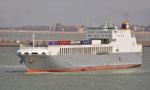
The Agwilines cargo service into San Juan from New York was operated from 1948 by war built C1, C2 and C3 types such as Agwimonte (ex Cape Alexander), Agwiprincess (ex Cape Spear), Agwistar (ex Cape Chalmers), Agwiking (ex Pampero) and Agwidale (ex Sovereign of the Seas). They discharged their cargoes into lighters owned by the Puerto Rico Lighterage Company inc. such as Ponce de Leon, Catano, Puerto Nuevo, Cabo Rojo and John E. Berwing of up to 191 grt. Agwilines was liquidated in 1953, and when freight began to be handled on trailers and in containers several standard war built C4-S-a3 types were used to San Juan, renamed as Aguadilla, Arecibo, Borinquen, Carolina, Guayama, Humacao, Mayaguez and San Juan. Three new ro-ros were completed in 1970 of 15,135 grt as Bayamon, Fortaleza and Ponce for service to Puerto Rico. Six container ships of 19,500 grt were in service to San Juan at the Millennium named Carolina, Guayama, Humacao, Mayaguez and Nuevo San Juan by the Puerto Rico Maritime Shipping authority. Cement was imported into San Juan in the converted C1-M-av1 type Cementos Ponce, and a fleet of coasters was operated around the Caribbean islands from San Juan by the Caribbean Navigation Co. inc., including Tapanahony built in 1950.
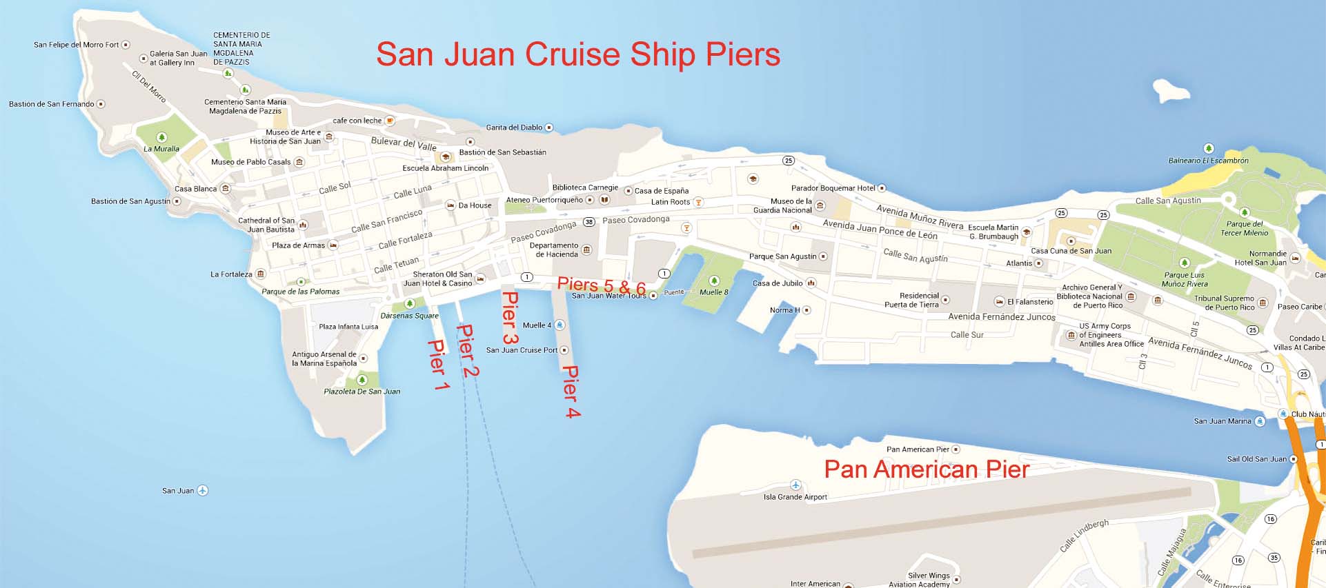
Americans do not need a visa when they visit Puerto Rico as it is American soil, and American tourists soon began to arrive on cruise ships. The port has one of the finest all weather harbours in the Caribbean, and is located on the south side of old San Juan island in the Bay of San Juan, with sixteen piers of which eight are used for passenger ships and eight for cargo ships. The Autoridad de los Puertos de Puerto Rico controls the port facilities, in addition to Luis Munoz Marin international airport, seven miles from the port, and the ferry services across the bay to Catano. The Port authority was formerly known as the Transportation authority of San Juan and is a public corporation created by the Territory act of the United States in 1942. a Board of Directors is headed by the Chief Executive Director, currently Bernardo Vazquez, with members representing the Dept. of Transportation and Public Works, the Dept. of Economic Development and Trade, the Dept. of industrial Development, and the Dept. of Tourism. The Port Head office is at 64 Calle Lindberg and the position of the port is at 18° 27′ North, 66° 6′ West.

The port and its docks are located along the San Antonio Canal, a narrow navigable section lying to the south of old San Juan, and north and west of the city areas of Puerto Rico. The municipalities of Catano, Guaynabo and modern San Juan comprise the south side of the bay and port.

The Port Of San Juan has the following piers:-
Pier 1 for smaller cruise ships e.g. those of Sea Dream Yacht Club, Sea Dream I and Sea Dream II of 4,333 gt with accommodation for 116 passengers.
Pier 2 for cruise ships, and for port maintenance vessels if not in use.
Pier 3 for large cruise ships and is the preferred berth of royal Caribbean international and its subsidiaries. it has split pedestrian and vehicle access to reach the shore in safety.
Pier 4 for large cruise ships and is the preferred berth of Carnival Cruises and its subsidiaries. Piers 1 to 4 are specially constructed moorings at right angles to the shore with cruise ships moored bow first to the quay.
Panamericano Pier I (East) for large cruise ships, and is the preferred berth of Celebrity Cruises.
Panamericano Pier II (West) for large cruise ships, and is the preferred berth of other major cruise lines.
Pier 8 is a general cargo berth with facilities to berth three ships at the same time on 590 feet of quay and five acres of open storage.
Pier 9 is a general cargo berth with facilities to berth three ships at the same time on 655 feet of quay and four acres of open storage.
Pier 10 for export goods in general cargo ships, ro-ros, as well as coastal cargo ships trading to the virgin islands.
Pier 11 is a foreign trade pier with 580 feet of quay, used mainly for the import of construction materials.
Pier 12 is an extension of Pier 11 with 550 feet of quay, used mainly for the import of construction materials.
Pier 13 is an extension of Pier 12 with a long quay and warehouse storage of 60,000 square feet and open storage of 23,000 square feet, used mainly for the import of construction materials.
Pier 14 is a foreign trade pier with 550 feet of quay, 90% used for the import of construction materials e.g. steel rods, steel beams, and wood for construction use.
Piers 15 and 16 for containers, automobiles and a berth for harbour tugs. The piers have a dry dock between them of length 632 feet with an alongside depth of 27 feet. The former Puerto Rico Dry Docks and Marine Terminals owned another floating dock for coastal vessels up to 3,000 dwt.
Crowley Pier for ro-ro operation and discharge of containers on trailers.
Navy Pier used by some cruise ships, car carriers, warships and yachts.

Puerto Nuevo Area Of San Juan
Army Pier used for container cargo and ro-ro operation by the companies intership and Trailer Bridge.
Piers A and B used for oil fuel, grain, wheat, flour and animal feed operations by the companies Panamerican grain and AEE (Autoridad de Energia Electrica).
Pier C used for container cargo by Luis Ayala Colon and Successors.
Pier D used for break bulk cargo e.g. wood, newsprint and paper for printing by island Stevedoring.
Piers E and F used for container cargo by Horizon Lines, owners of seven container ships on U.S. gulf, Alaskan and Hawaiian services, and was taken over by Matson Lines on 29th May 2015.
Pier G used for container cargo by Luis Ayala Colon and Successors.
Piers H, J and K used for container cargo by Sea Star.
Piers L, M, N and O used for container cargo by intership.
In total, the Port of San Juan has 22,700 feet of berths, 10.2 hectares of warehouse storage, and 13.9 hectares of open storage. The Bay entrance is 42 feet deep and constantly dredged, with the New Port Channel and San Antonio Canal of 36 feet depth, and the Sabana access Channel of 32 feet depth. Specialist American rock breaking equipment and barges have also been brought in to break up the rocks in the bay in shallower water and thus widen the shipping channel. The cargo piers are close to the Puerto Rico expressway system and several major local motorways, thus allowing for fast and efficient transportation of sugar and manufactured goods for export from the rest of the island.
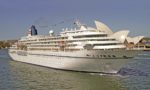
A total of 7.9 million short tonnes of cargo was handled as well as 1.25 million cruise passengers disembarked at the port in 2010 from five hundred cruise ships, with up to eight cruise ships berthed at the same time. The late 1970s saw cruise ships arriving such as Carla C of Costa Crociere, and Cunard Princess and Cunard Countess of Cunard Line to offer short one or two week Caribbean cruises. Today, Carnival Cruises and royal Caribbean international cruise ships predominate as major port of call lines on seven day east or west Caribbean cruises. The other current cruise lines arriving include Celebrity Cruises, Disney Cruise Line, Holland America Line, Norwegian Cruise Line (NCL), Princess Cruises, Costa Crociere, MSC Cruises, Azamara Cruises and Cunard Line. The arrangement of luxury hotels opposite the cruise ship piers allows passengers to stay on the island before or after their cruise. a short walk brings them to the major attractions of old San Juan and the Puerto Rico Convention Centre district.
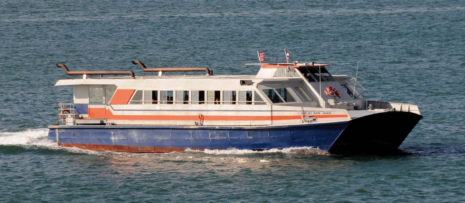
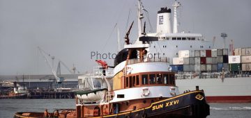
The cruise and freight ships are helped to their berths by ten harbour tugs owned by American Tugs inc., the largest being Alejandro of 485 gt, as well as part of the New York and New Jersey tug fleet of McAllister Towing and Transportation Co. inc. (MT&T) with eighty tugs of up to 450 gt. Small craft seen around San Juan harbour and bay include nine small ferries owned by the Puerto Rico Ports authority including Cayo Blanco, Cayo Largo and Cayo Norte traversing the bay to Catano. Larger tugs for towing barges are owned by the Puerto Rico Towing and Barge Company inc, including Honcho, Triton and guardian of 500 gt, and the University of Puerto Rico has two fishing research vessels named Islas Magueyes and Chapman of 430 gt.

Puerto Rico Imports, Exports And Fishing
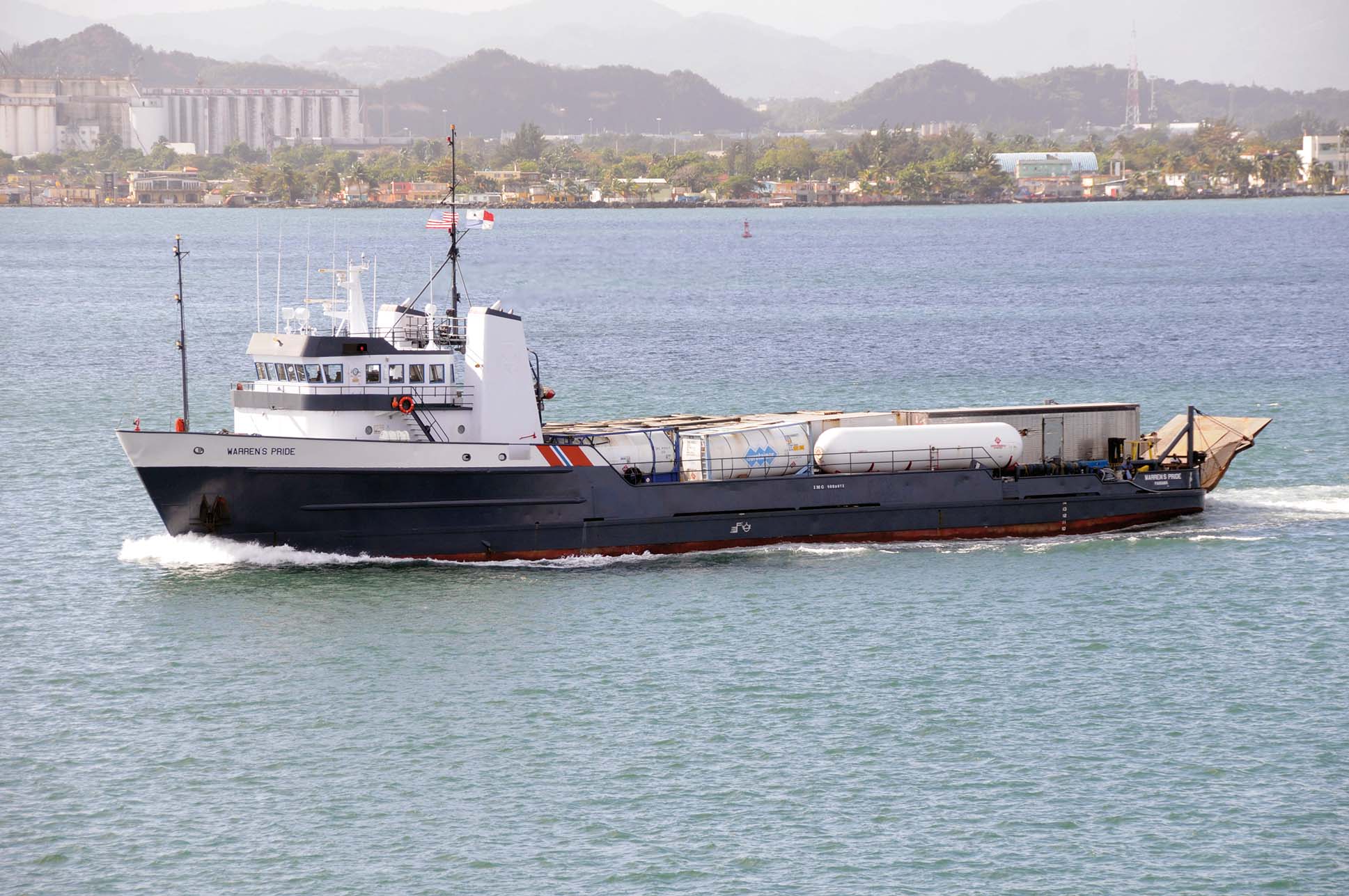
all maritime freight between Puerto Rico and the American mainland is controlled by strict cabotage laws, and must be carried using U.S. flag vessels. 60% of imports originate from American ports, and 75% of Puerto Rican exports are bound for the U.S.A. Crowley Maritime, founded in 1892 and currently based in Jacksonville, is one of the major U.S. carriers. Crowley Maritime has served San Juan since 1954 with several routes to the U.S. mainland ports. TMT Trailer Ferry was their first ro-ro service delivering groceries, furniture, shop merchandise of all types, building materials, cars, rum, and pharmaceuticals. Crowley ro-ro vessels are very low vessels with flat tops and green hulls, and unload their cargoes direct into wharfside warehouses via their ramps positioned at right angles to their pier in San Juan.
Puerto Rico imports are valued at 45,000 million dollars per year, covering food, supermarket supplies, mining equipment, petroleum and gasoline, coal, chemicals, pharmaceuticals, medicines, machinery, electrical, electronics and computers, cars, trailers and heavy earth moving equipment. Puerto Rican exports are valued at $62,000 million per year, covering manufactured products, chemicals, sugar, coffee, maize, pineapples, chemicals, pharmaceuticals, medicines, electronics and electrical components, and medical supplies. The Puerto Rican fishing fleet lands an annual big catch of Caribbean fish species, including barracuda, grouper, snapper, red mullet, jobfishes, Caribbean spiny lobster, conch stromboids and tilapias.
Ports In Other Parts Of Puerto Rico
Port Of Ponce
Ponce is the second largest port in Puerto Rico and can handle general cargo ships, ro-ros and cruise ships. it has undergone a significant expansion to convert it into a major shipping hub on the southern coast of the island. The port now has eight piers with a throughput of 250,000 TEU of containers, with the main exports being sugar, scrap metal, chemicals, clinker and cement, and the main imports of coal, lumber, molasses, syrup, chemicals and gypsum.
The port has one long quay, Muelle de Ponce, with a ‘T’ junction pier, and protection is offered by a curved breakwater and marina on the Isla de Gata. The port has been operated by the autonomous Municipality of Ponce since 1911, and became an important part of the sugar and coffee industries of the island. a covered pier of concrete and steel was completed in 1913, and at the end of World War I the port had a fifth of the island cargo traffic.
in the 1990s, the Port of Ponce railroad system used rail tanker cars for the import of oil, and a cruise ship terminal was completed with Celebrity Cruises and Holland America Line ships calling occasionally. a new quay crane was installed in 2005 as part of the expansion plan, which has created a major new cruise ship and container ship quay of length 1,200 feet to berth two cruise ships at the same time at a cost of $57.6 million. Dredging of the Bay of Ponce was completed in the years after 2006, and the spoil was used to reclaim eighteen acres of land to provide a container yard and quay with an annual throughput of 250,000 TEU. This part of the port is now known as the Rafael Cordero Santiago Puerto de las Americas and was completed in 2014.
Port Of Mayaguez And Other Ports
There are a total of thirteen ports on the island, with Mayaguez as the third largest port in Puerto Rico. it can handle general cargo ships, ro-ros and cruise ships, as well as the ferry service from this west coast port across the Mona Passage to Santo Domingo and Rio Haina container port in the Dominican republic. There are also other ports around the island e.g. at Arecibo for the discharge of oil fuel to supply the AEE (Autoridad de Energia Electrica) power station, at Yabucoa for crude oil discharge to the Shell-Buckeye oil refinery, at Guayama-Las Mareas for discharge of oil and petroleum products to supply the Autoridad de Energia y Suministro (Authority of Energy Supply facility), Guanica for grain and fertilizer discharge for Panamerican Fertilizer, and at Guayanilla-Tallaboa for discharge of asphalt, chemical, propane and butane and other liquid gases for Demaco, Pro Caribe and road building companies.
Postscript
The Port of San Juan has come a very long way since the Spanish conquered the island, which was known as Borinquen at that time after the original Arawak Indian name for the island of Borinquen. The United States of America defeated Spain in 1898, and gave the island their flag of five alternating red and white horizontal stripes of equal width, with a blue triangle bearing a five pointed white star. The only black mark in the enduring century long relationship with the United States concerns the Island of Vieques, which was used by the U.S. Navy for a very long period as an ammunition testing range. The island was littered with lethal ordnance, and after several accidental deaths of local people, protests forced the complete closure of the U.S. base on 31st March 2004.
Comments
Sorry, comments are closed for this item