Walvis Bay (Walvisbaai in Afrikaans and Walfischbai in German) is named after the bay on which the second largest city in Namibia is located on eleven square miles of land. Inland Windhoek is the largest city and capital of the country, however cooler Swakopmund on the coast is the summer capital. Windhoek is the home to both chambers of the Parliament of Namibia, which is called the Tintenpalast, or German for the ‘Ink Palace’. Walvis Bay has a natural sheltered harbour with deep water and is protected by the Pelican Point sand spit, and is the only natural harbour of any size on this very long coast. The coastal waters draw large numbers of Southern Right whales and fish shoals, attracting whalers and fishermen. The port is situated on the Tropic of Capricorn in the Kuiseb river delta, the river rising in the Khomas Highland west of Windhoek. The town with a population of 67,200 lies at the end of the Transnamib Railway built through the very challenging and hostile climatic regions of South West Africa. Walvis Bay is the centre of the guano collection industry, and has massive salt deposits and salt works behind the huge sand dunes.
HISTORY OF WALVIS BAY
A succession of colonists developed the area after Portuguese navigators explored the route down to Cape Town and India from 1485. Portuguese navigator Diogo Cao reached the northern part of Walvis Bay in 1485, followed by Bartolomeu Dias, and after Vasco da Gama (1460-1524) had discovered the sea route to India. Walvis Bay was founded in the 1790s as a stopover for sea travel to Cape Town and India, but almost no commercial activity took place until 1890.
German shipowners and traders had called into the Bay of Luderitz for many years. South West Africa extended between the Orange river in the south to Angola in the north, and was a turbulent country in which the Bantu, Hottentot, Namaqua and Herrero tribes carved out a bare subsistence living. The Herrero women wear colourful clothes copied from the wives of German missionaries, who arrived in the 19th century with big bustles and big horn shaped head-dresses. Cape Colony had slowly expanded northwards taking in Griqualand West, Great Namaqualand and Damaraland, and it was expected that the British would annex South West Africa or make it into a part of Cape Colony. However, only a limited amount of the land around Walvis Bay and the Guano Islands was annexed in 1894.
The British were thus startled when the German flag was run up at Luderitz Bay in 1883, and the whole of South West Africa was proclaimed a German protectorate in the following year. German expansion across the continent was thus imminent, and the spectre of a German colony from west to east across the whole of South Africa would stall British expansion northwards from the Cape. This forced the British to annex Bechuanaland, sharing a land border to the east of South West Africa.
Cecil Rhodes (1855-1902), a member of the Cape Colony parliament from the newly incorporated Griqualand West met President Paul Kruger (1825-1904) of Transvaal for the first time in January 1885 at a conference to discuss the Bechuanaland situation. These two men were completely different in character.
Paul Kruger had led the Boer (Afrikaner) rise of nationalism, and had taken part in the Long Trek of the Boers, and belonged to the most strict of Afrikaner religious sects, viewing the singing of Hymns as ‘wicked’. He was known as the ‘Lion of Rustenburg’ when meetings were held there to try and unite the Transvaal and the Orange Free State Boer provinces. Cecil Rhodes was a millionaire and a diamond magnate, who controlled vast corporations e.g. De Beers Consolidated Mines Ltd. and Consolidated Goldfields of South Africa, mining both gold and diamonds, and was known as the ‘Colossus’.
Cecil Rhodes took over as British Ambassador of Bechuanaland, however a battalion of British troops under Sir Charles Warren arrived in Bechuanaland and badly mishandled the situation by inflaming the Boer (Afrikaner) settlers by proposing to exclude all Dutchmen from the territory. This would isolate Paul Kruger in his Transvaal province in north east South Africa, with President J. H. Brand controlling the other Boer province of Orange Free State. The absence of an agreement on Bechuanaland led directly to the two bloody wars fought between the British and the Boers during 1899 to 1902. The mighty Orange River formed the border between South West Africa and South Africa, and also the southern border of Bechuanaland, with its tributaries of the Vaal and Hartz rivers flowing down from the Orange Free State and the Transvaal.
A decade later, a dispute then arose with German South West Africa regarding the boundaries of the enclave of Walvis Bay. German troops subsequently overran Walvis Bay in late 1914, with British and South African forces retaking the town in 1915. German South West Africa was thus a colony of the German empire from 1884 to 1915, with Germany finally recognising the loss of the territory in the Treaty of Versailles in 1919.
The capital was Windhoek with an area of 835,100 square kilometres (322,400 square miles) or 1.5 times bigger than the area of Germany at that time. The colony had a population of 2,600 German nationals until the Union of South Africa occupied the territory on 9th July 1915, assisted by British forces. German reprisals had taken place against the Herrero and Namaqua native African people rebellions and had resulted in a genocide between 1904 and 1908.
German South West Africa was then administered by a League of Nations mandate by the Republic of South Africa, until it became the independent country of Namibia on 21st March 1990. Bechuanaland had become the independent country of Botswana in 1966. Many German names, buildings and businesses today still exist in Namibia, and up to 30,000 people of German descent still live here today. German newspapers, satellite TV stations, and radio channels are beamed from Windhoek or from Germany. The first stamps used in the German colony were overprints of German stamps in May 1887, the colony then had a long run of the ‘Yacht’ issue of their own stamps from 1900 to 1919 and featuring a German passenger liner.
Walvis Bay and the land around it had never been a part of the territory of German South West Africa, and the Republic of South Africa was awarded control of the town in 1921/22 under a mandate of the League of Nations. Control of Walvis Bay was returned to Cape Colony in 1977, and became a constituency of Cape Town in 1982. In 1990, on the independence of Namibia, Walvis Bay remained under South African sovereignty with South Africa increasing the number of its troops in the town. In August 1993, and the end of apartheid rule in South Africa, a resolution was passed to integrate Walvis Bay and the offshore islands into Namibia. This transfer formally took place on 1st March 1994.
A double fence protected the whole length of the border between South West Africa and Botswana, which was patrolled by the South African Defence Force (Army). On the independence of Namibia in 1990, this force was withdrawn and the fence was cut to allow free movement of people, cattle and wild animals e.g. kudu. On both sides of this fence, huge swarms and hordes of bloodthirsty tsetse flies and mosquitos emerge each year to attack both humans and animals. The latter is a ‘silent biter’ using its proboscis as a fine needle to suck blood, while the former is a ‘slasher’ with mouth parts like scissors that chop a hole in the skin or hide to drink from the pool of blood. Tsetse fly and mosquito eradication uses spraying at night with a powerful killer spray by aircraft in ten miles long sections, with special attention paid to the margins of the area to stop the dreaded fly from recolonising the area.
Malaria carried by infected mosquitos can be fatal even ten years after being infected, as was the case with an uncle of mine, Charles Lea, while fighting with the Eighth Army in Southern Italy in 1944, dying of the disease in 1954. On entering the blood system, the parasites enter the red cells and, after multiplying, eventually burst them. These invasions bring on the recurrent bouts of chill and fever typical of the disease. Repeated attacks cause anaemia and enlargement of the spleen and liver. Travellers to malarial infected areas must take preventative drugs to prevent or cure malaria.
THE PORTS OF WALVIS BAY AND LUDERITZ
The Port of Walvis Bay was formed on 28th February 1994 and began container handling operations soon after, with 30,000 TEU handled in Millennium year, 370,000 TEU handled in 2016, and upgrades to one million TEU per year for the foreseeable future. There are currently ten large, international fishing companies based in Walvis Bay, catching large quantities of mackerel, anchovies, white steenbras, kabeljou, kingklip, hake, catfish, tuna, sardines and snoek. The National Fishing Corporation of Namibia (Fishcor) opened a new fish processing plant in September 2018 as one of the largest pelagic processing plants in South Africa with a throughput of 80,000 tonnes of fish per year. The former heavy lift vessel, Aberthaw Fisher built in 1966 for Sir James Fisher & Sons of Barrow, was owned by Benguela Sea Products at Walvis Bay as a diamond mining vessel under the name of Moonstar in Millennium year.
Walvis Bay Airport is simply an airstrip in a nearby oasis in the immensity of the Namib Desert with a few trees, and two large terminal buildings. Walvis Bay has many sights and hotels e.g. the Walvis Bay Church with a tall, slender spire and a porch with a large door and an upper glazed window, while the good, clean beaches have dolphins, seals, pelicans, flamingos, with the seas used for oyster cultivation for export, as well as for small boats taking tourists on exciting whale watching expeditions.

The Port of Luderitz is situated 225 miles to the south of Walvis Bay and is the only other and the second port in the country, with Swakopmund lying 55 miles to the north of Walvis Bay used by the Germans as a small port during their occupation of German South West Africa. The Port of Walvis Bay began life on 28th February 1994 when Walvis Bay was integrated into Namibia, and the Namibian Ports Authority (NAMPORT) Act was passed for control of the port, and also for the Port of Luderitz. The lighthouses at Pelican Point and at Diaz Point were both transferred to NAMPORT on 15th March 2020. The Head Office of NAMPORT is at Rikumbi Kandanga Road in Walvis Bay, and the year by year landmarks in the development of NAMPORT have been during this short span of 25 years:-
1995 Cold Storage Unit for the fishing fleet at Walvis Bay was opened and extended.
1996 First export of a large cargo of 36,000 tonnes of salt in bulk made from Walvis Bay.
1997 First mobile crane purchased for the Port of Walvis Bay, and the new Headquarters Building was completed.
1999 The new tug Cormorant, the fifth in the port fleet, was ordered from Denmark.
2000 Deepening of the approach channel to the Container Terminal and Berths 1 to 3 and the turning basin circle to 12.8 metres took place. The Pelican Point and Diaz Point lighthouses were fully automated, and the lightkeeper lodges were no longer required.
2002 The Port of Luderitz waterfront project was completed with a long single general cargo quay and two large warehouses with mobile cranes and a large container storage yard. The Marine Pollution Combat Centre at Walvis Bay was opened.
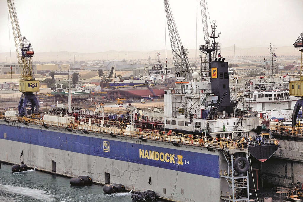
2003 The Synchrolift facility for yachts and small vessels was expanded.
2004 The tenth anniversary of the port was celebrated, and the new Namport Hub strategy included a new Namibia to South America direct container service.
2006 A Floating Dock for repair operations came into service with a lift capacity of 8,000 tonnes under a public and private partnership agreement with Elgin Brown and Hamer Namibia (Pty) Ltd. A second floating dock of higher lift capacity followed in 2008, and a third floating dock of 15,000 tonnes capacity came into operation in 2013.
2009 First oil rig berthed at Berth 8 in the Port of Walvis Bay.
2011 Alongside depths at all berths in the Port of Walvis Bay was increased to 14.0 metres, and container handling capacity increased to 355,000 TEU per year from 250,000 TEU per year.
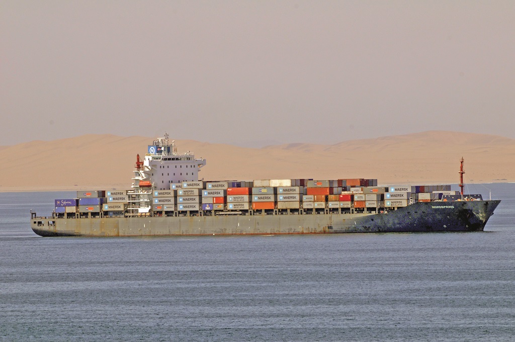
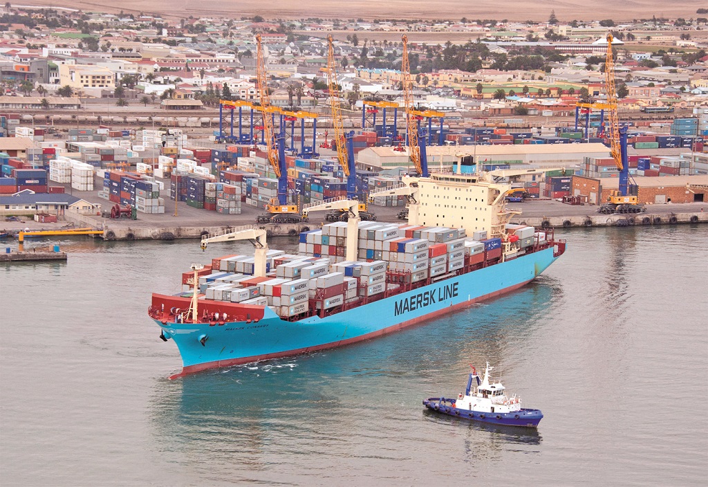
2011/12 Maersk Line began a WAFMAX service into Walvis Bay with the first container ship Maersk Conakry berthed in June 2011.
2014 Planning for a new and much larger container terminal began. The Port of Luderitz land limits were extended northwards to Angra Point with the aim of developing a deep water port. CMA CGM began to call at Walvis Bay on an Asian to Africa service with container ships of 5,700 TEU capacity, first ship to berth was ER Canada.
2015 A new port rail network project began at the Port of Luderitz, and preparatory work for the establishment of a Cold Storage Unit at the port was begun. The Port of Walvis Bay Petroleum Liquid Bulk Terminal opened in late 2015 to be managed by Namport for the SADC Gateway (South African Development Community) Oil Terminal.
2019 The new Port of Walvis Bay Container Terminal on reclaimed land was opened on 24th August 2019 on a square area with three berths at the mouth of the Kuiseb river, and had the facilities of four gantry cranes, two mobile cranes, and several reach stackers to store containers on a large concreted area before onward movement by rail and road.
2020 The Port of Walvis Bay had imports of petroleum, fish and fish products, sulphuric acid, vehicles, copper and lead concentrates, sugar, coal, machinery, chemicals e.g. sodium carbonate, wheat, spare parts, wooden products and other general cargo. Exports included salt, fish and fish products, manganese ore, copper and lead concentrates, lithium ore for mobile phone and battery production, fluorspar, marble and granite, scrap steel, zinc ore concentrates, flat cartons, building materials and other general cargo.
Trans-shipped containers and general cargo formed a big part of the port traffic in its first years. Berth numbers of the Port of Walvis Bay are as follows:-
Berth 1 Mainland berth of length 165 metres, alongside depth of 14.0 metres
Berth 2 Mainland berth of length 165 metres, alongside depth of 14.0 metres
Berth 3 Mainland berth of length 165 metres, alongside depth of 14.0 metres
Berth 4 Mainland berth of length 225 metres, alongside depth of 14.0 metres
Berth 5 Mainland berth of length 225 metres, alongside depth of 14.0 metres
Berth 6 Mainland berth of length 225 metres, alongside depth of 14.0 metres
Berth 7 Mainland berth of length 225 metres, alongside depth of 14.0 metres
Berth 8 World Class Oil Rig Servicing Berth
Berth 9 New Container Terminal 200 metre long quay, alongside depth of 15.0 metres
Berth 10 New Container Terminal 200 metre long quay, alongside depth of 15.0 metres
Berth 11 New Container Terminal 200 metre long quay, alongside depth of 15.0 metres
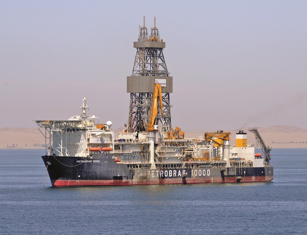
The World Class Oil Rig Servicing Berth 8 at the Port of Walvis Bay opened in 2009, and typically receives mammoth semi-submersible oil rigs such as Transocean Marianas of the SEDCO 700 design of length 91.44 metres and beam of 75.90 metres for maintenance work to be completed. She is owned by Triton Asset Leasing Gmbh and is capable of drilling in 7000 feet of water to a maximum drill depth of 25,000 feet in the harshest of environmental conditions. She is of 20,491 grt and arrived at Walvis Bay in February 2013 to undergo maintenance work of three to four weeks duration before starting drilling in the Wingat Oil Prospect of the Walvis Oil and Gas Basin. She had arrived from Ghana after fulfilling a three year drilling contract to ENI of Italy in offshore Ghana. The rig is owned by HRT Walvis Petroleum (Pty) Ltd.
The most powerful XBOW design tug ALP Striker in the world arrived at Berth 8 of Port of Walvis Bay in April 2020 while towing the four legged semi-submersible rig West Bollsta from Seoul in South Korea to Norway. She is the first of four sisters with black hulls and ‘ALP’ in bold orange letters emblazoned on her bow, and is owned by ALP Maritime Services, a subsidiary of Teekay Offshore Partners. She was handed over at her Nigata building yard in Japan on 13th May 2016 at a ceremony attended by seventy oil and gas industry representatives. She is of the Ulstein SX157 design with a bollard pull of 300 tonnes for ultra long distance towing of rigs or for anchor handling of these enormous drilling platforms. The sisters are ALP Defender, ALP Sweeper and ALP Keeper with a cruising speed of 13 knots, towing speed of 5 knots with a distance of 2 kilometres between tug and rig, and free running speed of 19 knots. The class have fuel tanks of 3,500m3 or enough for them to tow at full speed for 45 days around the world from four main engines of 18,000 kilowatts power. They have cargo deck areas of 550 square metres for a maximum deck cargo of 2,400 tonnes, and have Dynamic Positioning Class II, Ice Class 1B, and high quantity foam and water firefighting abilities. West Bollsta is managed by Seadrill and is capable of operating in harsh environmental conditions and ultra deep water up to 10,000 feet in depth with a maximum drill depth of 40,000 feet. Fred Olsen Energy originally ordered the rig from Hyundai at Ulsan, but cancelled it in 2015 as a result of delays in the delivery date. The rig was then completed in December 2017 after being sold to Northern Drilling with dimensions of 403.0 by 255.0 by 33.0 feet, and her first drilling job was in the Barents Sea on charter to the Swedish oil and gas company Lundin.
There are also two existing oil tanker berths in the port owned by the Ministry of Mines and Energy. The port handles breakbulk, dry bulk, liquid bulk, multi purpose cargoes, with a ship repair facility having a Synchrolift of 2,000 tonnes capacity, as well as railway marshalling yards with rail cement wagons for export, warehousing and cargo storage areas, a fish landing quay, cold freezer storage facilities, and a cruise ship jetty built out from the mainland and parallel to the causeway leading to the big 40 hectare Port of Walvis Bay Container Terminal. The South African Development Community (SADC) has future development projects with Phase 1 for the provision of two new tanker berths of 60,000 dwt with their product pipelines and access trestles, Phase 2 for a big LNG Terminal with their product pipelines and access trestles, and Phase 3 for a 10 million tonnes per year dry bulk terminal handling coal, ores and other dry bulks.
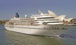
The cruise ship jetty sees arrivals of many cruise ships from the fleets of Aida Cruises, Phoenix Seereisen, TUI Cruises, Hapag-Lloyd Cruises, Oceania Cruises, Regent Seven Seas Cruises, Silversea Cruises, Norwegian Cruise Line, Azamara Cruises, Costa Cruises, Cunard Line and other cruise lines. Shore excursions are arranged to all of the best sight seeing and holiday facilities in Walvis Bay, as well as for whale watching cruises and visits to modern beach resorts.
NAMPORT STATISTICS (mtonnes)
PORT OF WALVIS BAY
2016/17 2017/18 2018/19
Imports 3.2630 3.0625 3.4583
Exports 1.3318 1.4305 1.7474
Transshipped 0.5733 0.3329 0.1690
TOTAL 5.1671 4.8259 5.3747
PORT OF LUDERITZ
2016/17 2017/18 2018/19
Imports 0.1558 0.1771 0.1557
Exports 0.2001 0.2362 0.2068
Container 0.0313 0.0477 0.0422
TOTAL 0.3872 0.4610 0.4047
PORTS OF WALVIS BAY + LUDERITZ
2016/17 2017/18 2018/19
TOTAL 5.5543 5.2869 5.7794
SHIP VISITS 2,080 1,816 1,720
THE SKELETON COAST SHIPWRECKS
The Skeleton Coast to the north of Walvis Bay is the northern part of the South Atlantic coast of Namibia and south of Angola from the Kunene river to the Swakop river. The name is also used for the whole of the Namibian coastline on the South Atlantic. This endless, dangerous coastline of the Skeleton Coast can be deadly to the crews of wrecked ships as behind the coastline is the vast emptiness of the entire Namib Desert. Rescue could take up to several days or weeks overland to a shipwreck in a remote location. The very strong currents and undertows lead ships quickly inshore to their sandy graves, from which they cannot reverse out, but the primary cause of hundreds of shipwrecks on this inhospitable coast are the dense early morning fogs that trap the unwary navigator and leave the ship stranded hundreds of miles from any form of civilisation. Some wrecks are now entombed in sand over 800 metres inland from the beach, and the crashing waves quickly reduce strongly built hulls into only a few mangled plates or the main engine block sitting forlornly on the beach at a crazy angle.
The Portuguese navigators described this coastline as ‘The Gates of Hell’ with huge surf on long beaches and occasional rocky outcrops, and they were only able to land through the surf and it was almost impossible to launch back out again from the shore due to the size of the waves and the undertow. The upwelling of the Benguela current gives rise to dense ocean fogs called ‘cassimbo’, with the winds always blowing from land to sea and rainfall at a meagre 0.39 inches per year. The only land route out is through a hot and arid desert with occasional marshes of hundreds of kilometres in length. The coastal landscape is dominated by high sand dunes and immense crashing waves on the beaches.
The Skeleton Coast derives its names from the bones of whales littering the shore from the whaling industry, although in modern times the skeletal remains of many wrecked ships lie slowly sinking into the sand. The Skeleton Coast is one of the few coastal names that have taken their name from a book, in this case a classic 1944 book by John H. Marsh when he wrote about the wreck of the Blue Star cargo-liner Dunedin Star. The name of the Skeleton Coast has now superseded all previous names on official maps. The skull and crossbones flags flying at the entrance to the Ugab River Gate entrance to the Skeleton Coast National Park are there for a very good reason. There have been hundreds of shipwrecks, and several of these will now be described in detail.
The oldest wreck on this coast was discovered in April 2008 and turned out to be the 500 year old Bom Jesus Portuguese sailing ship, which had sailed from Lisbon in 1533. After almost two years of careful conservatory work, the remains of the vessel were successfully salvaged from the seabed off Oranjemund. A huge hoard of 2,266 gold and silver coins were found under the planks of her wooden deck, and these Portuguese and Spanish coins were placed under lock and key in the safe hands of the Bank of Namibia. Archaeologists also recovered cannon and artefacts to help them trace the history of Portuguese navigators along the Skeleton Coast.
The motor vessel Dunedin Star was a refrigerated cargo-liner of Blue Star Line that was launched on 29th October 1935 at the Birkenhead yard of Cammell, Laird, and was completed in February 1936. She belonged to the ‘Imperial Star’ class of Blue Star Line with enough range to serve the frozen meat trade from Australia and New Zealand to the U.K. Dunedin Star relieved the siege of Malta during Operation Halberd in September 1941, and left Liverpool on 9th November 1942 for the Port of Suez in Egypt via Saldanha Bay, Cape Town and Aden carrying munitions, vehicles for the British Eighth Army fighting the German Panzers in North Africa. She had a crew of 85 and 21 passengers and sailed initially in convoy ON145 for New York, but soon detached from convoy and headed to the South Atlantic. However, she ran aground on the Skeleton Coast at 2230 hours on 29th November 1942 after striking the Clan Alpine shoal. A radio distress message was received at Walvis Bay, but she was far to the north of the Skeleton Coast about 50 miles south of the Cunene river on the border with Portuguese Angola.
Capt. R. B. Lee chose to beach his ship for the safety of the crew and passengers as she was rapidly taking on water and the pumps could not cope with the inrush. She was very firmly aground 500 yards from the shore, and her Master feared she would break up, and so he lowered the motor lifeboat and started putting people ashore. Two trips took 63 people to safety including eight women, three babies and a number of elderly men. Capt. Lee and 42 other people were left onboard after the motor lifeboat broke up in the pounding surf. The eventual rescue of all 106 souls was at the cost of a steam tug, an SAAF aircraft, and the lives of two rescuers.
The South African Railways and Harbours tug Sir Charles Elliot of 328 grt sailed from Walvis Bay and headed north to reach the wreck. The minesweeper Nerine of 197 grt, a converted civilian craft, also sailed from Walvis Bay at 1400 hours on 30th November with emergency supplies packed into Carley floats to take ashore to the survivors on the beach. Temeraire of Wilhelm Wilhelmsen and Manchester Division of Manchester Liners stood by offshore after being diverted to help. A land rescue convoy from Windhoek set off into the desert led by Capt. J. W. B. Smith.
The rescue flotilla reached the wreck on 1st December 1942, with all 42 men taken off by Nerine, and boats from Temeraire to transfer them either to the tug or Manchester Division, a feat of some seamanship after the motor boat from Temeraire lost power after shipping a lot of water, and its Norwegian crew rowed for one hour and a half to reach Manchester Division. The rescue now turned to those huddled together on the beach for warmth, with a South African Air Force Lockheed Ventura plane dropping supplies on 3rd December with most disintegrating on impact. The pilot then decided to land behind the beach on a flat piece of land, but this salt pan disguised soft sand underneath with the wheels and undercarriage of the plane soon sinking through the crusty salt surface leaving the aircraft trapped in the soft sand and unable to take off again.
Several flights per day were then flown by other Ventura aircraft over the coming days, and also for the land convoy coming from Windhoek. This convoy reached Rocky Point on 8th December, where the tug Sir Charles Elliot had grounded with the crew swimming ashore although two crew members did not survive. The land convoy took her survivors to a makeshift landing strip where they were picked up by another Ventura aircraft. The minesweeper Nerine had returned to Walvis Bay for refuelling, and on her return to the wreck had taken off 26 survivors from the beach by the 10th December.
The land convoy then reached the remaining survivors on the beach and gave them food and warmth, before the eleven trucks of the convoy set off to return to Windhoek, reaching there on 23rd December, where the survivors convalesced for a short time before taking the Transnamib train to Cape Town. The stranded Ventura aircraft had a rescue party sent to recover the plane, and after four days of digging finally got the plane airborne on 29th January 1943. After a flight of only 43 minutes, the plane developed engine trouble and crashed into the sea off Rocky Point. The three aircrew survived and swam ashore, but the whole rescue effort had cost the loss of a large steam tug, an aircraft, and the lives of two rescuers. Capt. R. B. Lee was found culpable of the loss of his fine ship at the subsequent Court of Enquiry and was dismissed by Blue Star Line. He purchased a pub as a publican but the scarcity of Masters during World War II gave him one more ship for one of the Allied landings in Europe. At the end of war, he emigrated to India, where he died a few years later.
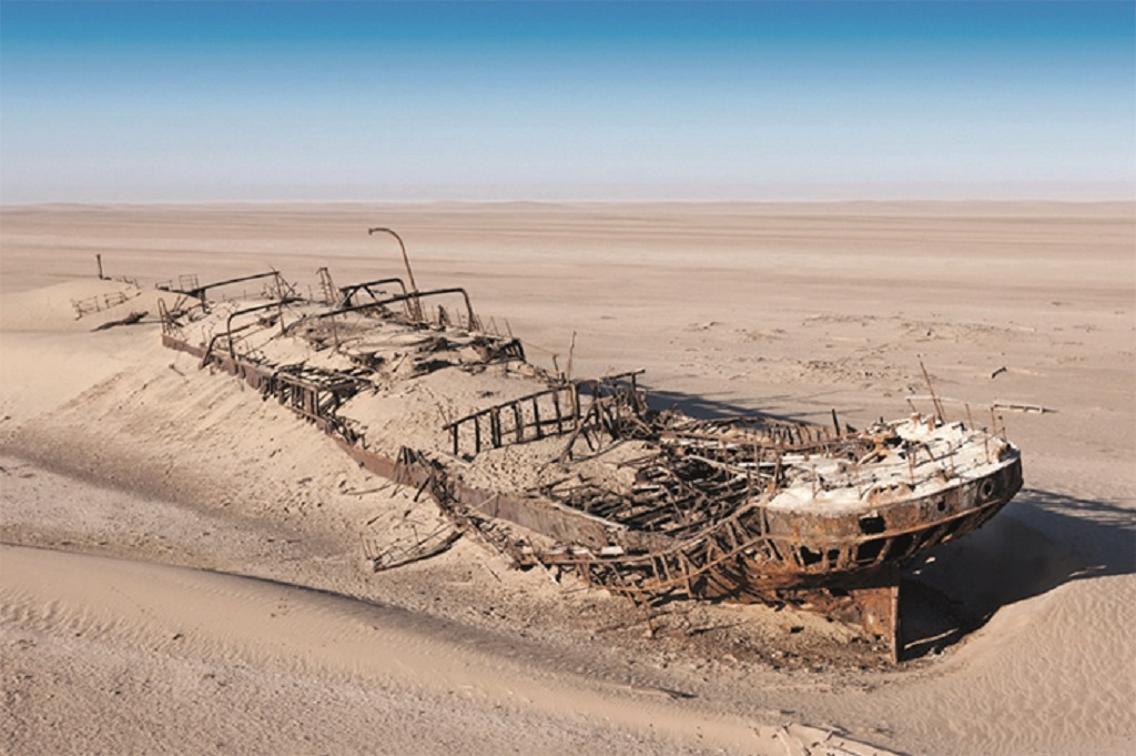
The German cargo ship Eduard Bohlen (above) of 2,272 grt and built by the famous Blohm & Voss yard in Hamburg in 1891 for Woermann Line, also ran aground in thick fog on 5th September 1909 at Conception Bay while on a voyage from Swakopmund to Cape Town. She had 32 First Class passengers and 14 Second Class passengers onboard, with these and all of her crew rescued. The wreck lies quietly disintegrating and sinking into the sand near two other wrecks, one being the Otavi, which ran aground here and was wrecked in 1945.
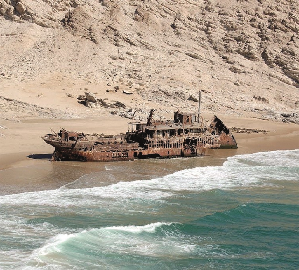
Otavi (above) was an engines ‘midships coaster of 687 grt that had been completed in 1919 by the Framnaes Mek Verksted yard at Sandefjord under the name of Lita for Gogstad & Company of Oslo. She was fitted originally with a Bolinders of Stockholm gas oil engine until it was replaced by a triple expansion steam reciprocating engine. She was sold to the Liverpool fleet of R. P. Houston & Company in 1927, keeping her name, but a year later was renamed Otavi for the Thesen Steam Ship Company of Cape Town. She loaded a cargo of guano in the Guano Islands near Walvis Bay on her last voyage but ran aground in Spencer Bay, Namibia. The aft part of the wreck is recognisable and lies today in the sand with the sea washing through it constantly.
Gertrud Woermann of 4,603 grt was completed by the Neptune yard of Wigham Richardson on the Tyne in 1893 as Pfalz for North German Lloyd. She had dimensions of overall length of 360.0 feet, moulded beam of 43.5 feet and moulded depth of 26.1 feet with accommodation for 100 First Class passengers and 360 emigrants or troops in the holds. She was powered by a triple expansion steam reciprocating engine and achieved a speed of 13.1 knots on trials, the shipbuilder making a profit of £3,923 on the contract price of £70,000. She was sold to Woermann Line in 1904 and renamed Gertrud Woermann and sailed from Hamburg to Swakopmund with general cargo on her last voyage in October 1904. She ran aground in thick fog on 19th November 1904 with all passengers and crew rescued by the gunboat Vineta, which was on a visit to Swakopmund at the time and assisted the stricken ship. The wreck was visible until 1912, when she disappeared under the water in a heavy storm. Today, the Gertrud beacon marks the spot where the remains of her hull lies.
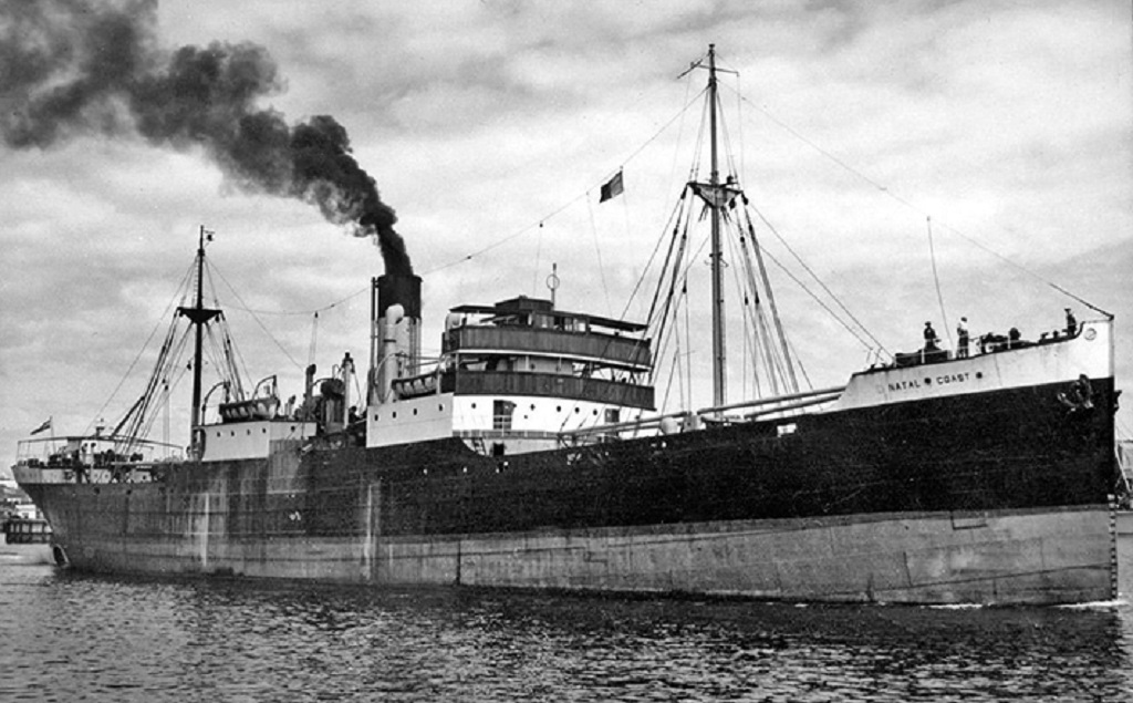
An old World War 1 standard three island ‘C’ class standard tramp, the Natal Coast, (above) was underway from Matadi to Cape Town with a large consignment of coconuts onboard when she stranded in thick fog on 30th April 1955 approximately thirty kilometres north of Swakopmund. The crew were rescued by breeches buoy, and a local scrap dealer eventually scrapped the hull, with only part of her engine room and boilers left on the beach as her visible remains. She was lost under the name of Natal Coast, but had been laid down as War Cloud of 3,078 grt and completed as Glenstal for the Limerick Steam Ship Co. Ltd. She was sold in 1951 to the Neptune Shipping Company of Durban and renamed Natal Coast, and grounded at position 22°30′ South, 14°27′ East.
The former Jadranska Plovidba vessel Vipava was carrying 350 tons of paper and 220 tonnes of steel plate as well as railway lines from Yugoslavia to Khorramshahr after having been sold to Iran, when she grounded on 7th July 1968 in thick fog 16 miles north of Swakopmund. The fuel tanks were punctured and her Master shut down her engines as the fuel was contaminated with sea water. A tug, Otto Siedle, tried in vain to pull the vessel off the sandbank but the towrope broke, and by a few days later her hull split open and water had seeped into the engine room and she was lost. The wreck site was at the Mile 14 campsite, and years later only the main engine block was visible at low tide.
Many trawlers had been lost on this coast as offshore there are huge shoals of fish as well as plankton for whales. Past human occupation also existed on the fish and on white mussels, with large shell middens still visible at places.
The Brazilian bulk carrier Frotamerica of 35,000 dwt had been built in 1979 by Estaleiro Ilha in Brazil and after a career of 34 years was under tow for breaking up. However, she cheated the breaking up squads and was wrecked near Anichab rocks, Namibia on 15th February 2013.
The Greek cargo ship Achillet of 5,281 grt and built in 1940 was wrecked to the north north west (NNW) of Walvis Bay in 1971.
The Korean cargo ship Tong Taw was wrecked in Spencer Bay, Namibia on 30th September 2014.
The coaster Balgowan of 286 grt, built by the Dundee Shipbuilding Company in 1897 for local owner William Kinnear, was sold to Bucknall Line in 1904 and was also wrecked in Spencer Bay on 9th August 1904 while carrying a cargo of fodder and a large quantity of candles.
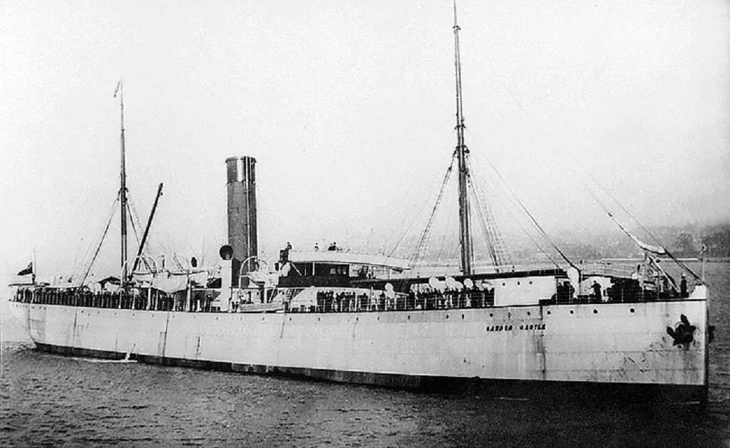
The Union Castle Line passenger ship Cawdor Castle (above) was built in 1902 by Barclay Curle & Company on the Clyde with accommodation for 40 First and Second Class passengers and 500 in emigrant class in the holds. She went ashore on 30th July 1926 at Conception Bay in South West Africa and became a total loss while on a voyage from London to Port Louis on Mauritius.
The French cable ship Vercors was built in 1975 by Societe Nouvelles des Ateliers & Chantiers du Le Havre for France Cables, and was one of the first cable ships to be fitted with a plough launched by an ‘A’ frame over the stern for cable burial and protection from trawling. She was of 5,886 grt with dimensions of 433.0 feet by 59.5 feet by 24.6 feet and was twin screw from diesel electric propulsion to give a service speed of 16.9 knots. She carried a large crew of 115 men for specialist cable laying and repairing around the world laying coaxial telephone cable. She worked for 23 years for France Telecom including contracts for the SEA-ME-WE3 system in the Far East, and was then renamed Chamarel by France Telecom-Orange. On 8th August 2012, she was destroyed by fire 68 miles north of Henties Bay in Namibia while returning from a cable repair job from Cape Town to Europe on the SAT3-SAFE cable system. The crew of 56 were safely rescued before the ship was completely engulfed in flames and she drifted ashore 30 kilometres from Henties Bay two days later.
Some of the trawlers lost were:-
On 22nd March 2018, a Japanese registered trawler Fukuseki Maru, got into trouble and ran aground near Durissa Bay, south of the Ugab river mouth around 200 kilometres from Walvis Bay and two kilometres offshore. All two dozen of her crew were safely rescued by helicopters of the Namibian authorities.
The South African trawler Winston, built in 1961 and owned by Agterbaai Fish Trust, ran aground on 17th October 1970 about 23 kilometres north of the Mile 108 campsite and was lost.
The fish factory ship Suiderkus had a very short life as she was lost on this coast on her maiden voyage on 16th January 1977 near Mowe Bay. The sophisticated navigational system had failed to alert the officers that she was too close to the shore, and only a few scraps of mangled steel were visible a few months later.
The trawler Zeila was under tow from Walvis Bay to Mumbai for scrapping after being sold by Hangana Fishing of Walvis Bay when she stranded on 25th August 2008 about 14 kilometres south of Henties Bay.
The trawler Benguela Eagle of 78 grt was lost on 5th June 1973 when 25 kilometres north of the Ugab river.
The fishing trawler Islander of 139 grt was lost in July 1973 after running aground close to the Angolan border with the loss of one crew member. She was a new trawler built at San Diego in the previous year.
The trawler Atlantic Pride was wrecked between the Huab and Koichab rivers near Torra Bay in the 1970s.
The trawler Anita II foundered in Henties Bay in 1968.
The trawler Gethen stranded in Henties Bay on 26th January 1954 and was lost.
The trawler Henrieta Spasheti grounded on 14th July 1968 when 165 miles north of Henties Bay, all ten crew were saved.
DE BEERS GIANT DIAMOND MINING VESSELS
Diamonds were first discovered in German South West Africa in 1908 and in Offshore Namibia in the 1960s, and so far have produced 95 million carats of diamonds. De Beers expanded Consolidated Diamond Mines from a base at Oranjemund. The Namdeb Mining Corporation (Pty) Ltd. was formed in the early 1990s with seven licences covering 16,000 square kilometres. Dimond deep water mining had begun in 1989 with the vessel Louis G. Murray finding 29,000 carats in 1990. The Government of Namibia and De Beers agreed to collaborative mining in 2000 and that mining must migrate to Namibia from South Africa whilst ensuring no interruptions to production. Four diamond mining vessels were purchased from Glomar in 2001. Debmarine Namibia was set up in 2002 by De Beers and the Government of Namibia, with mining taking place between 120 and 140 metres below sea level. Diamond mining is the single biggest contributor to the Namibian economy, with $715 million in revenue annually.
Seabed mining uses a horizontal crawler of up to 280 tonnes in weight when lowered to the seabed and dredges up large quantities of sediment, mud and rock in quantities of 60 tonnes per hour. Alternatively, airlift drill technology is used with a drill bit working in overlapping circles on the seabed. The dredged material is then washed and sifted using vibrating racks and rotating drums to crush the rocks, and reveal the diamonds. The diamonds are sealed in small barcoded containers and flown by helicopter three times per week to vaults onshore. Production of diamonds reached the one million carats mark in 2006 and 1.273 million carats in 2014. The Government of Namibia increased its shareholding in the joint Debmarine Namibia company to 50% from 15% in 2011. The following diamond mining dredgers have been used by the company since 2002, as well as chartered vessels:-
DEBMAR PACIFIC built in 1977 as Glomar Pacific of 8,565 grt and 6,667 dwt.
DEBMAR ATLANTIC built in 1978 as Glomar Atlantic of 8,628 grt and 6,718 dwt.
CORAL SEA built in 1974 as Glomar Coral Sea of 6,000 grt and 5,650 dwt
DOUGLAS BAY built in 1976 as Coba of 2,000 grt and 3,705 dwt
LOUIS G. MURRAY built in 1978 as Installer of 3,467 grt and 3,688 dwt
VOYAGER 1 built in 1983 as Shinsho Maru of 5,801 gt and 5,980 dwt
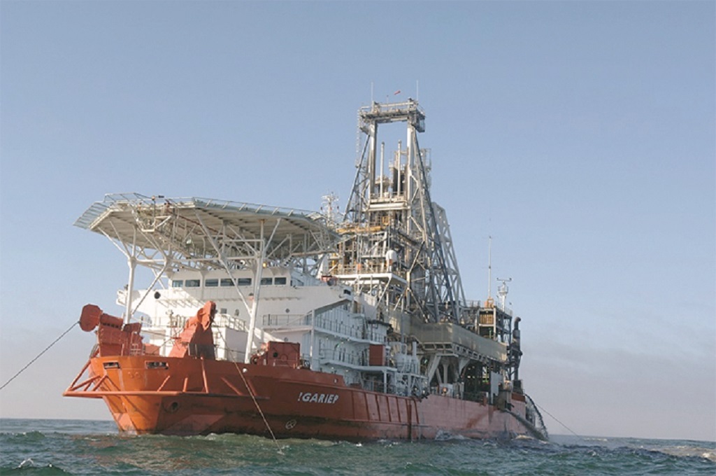
!GARIEP (above) converted on the Tyne in 2003 by A & P (Tyne) from the crane ship Voyager built in 1983 by fitting a new 300 tonne midbody fabrication block for washing and sifting work. 8,471 grt and 5.939 dwt and originally built by Tsurumi in Yokohama.
GRAND BANKS formerly the Glomar Grand Banks drilling rig built in 1972 of 6,168 grt and 6,648 dwt.
MAFUTA, formerly Dock Express 20 of Dockwise and built in Heusden in Holland in 1983. She was purchased in 2005 and renamed Peace in Africa after being converted by A&P (Tyne) into a diamond dredger of 174.0 metres overall length, taking her present name of Mafuta in 2013. Crews on all vessels work 28 days onboard followed by 28 days shore leave.
NUJOMA a $157 million deepwater diamond exploration and sampling vessel named after the President of Namibia in a joint venture by De Beers with the Government of Namibia and completed in June 2017. She was built by Kleven Verft Shipbuilders in Norway with an overall length of 112.8 metres and a displacement tonnage of 12,000, and her crew of 80 arrive at the vessel by helicopter to land on the forward helideck.
DEBMARINE NAMIBIA, a diamond mining vessel came into service in 2021, completed by the Kleven Verft yard in Norway at a cost of $142 million and an overall length of 176 metres with a crew of 130.
POSTSCRIPT
Namibia has as its western border the rough surf and beaches of the Skeleton Coast, it shares land borders with Zambia and Angola to the north, Botswana to the east, and South Africa to the south and east. The name of the country is derived from the parched Namib Desert, the oldest desert in the world. Walvis Bay is the only port in the country with a wide, natural harbour, and is forging ahead with many new trades and port construction work.
Whereas, the Government of South Africa has owned warships and merchant ships for decades, the Government of Namibia only formed its Navy in 2004 with extensive Brazilian assistance. The Maritime Wing Headquarters of the Namibian Navy began to be constructed in the Port of Walvis Bay in 2000, and a contract was then signed in 2004 for the delivery of three patrol boats, each of 200 tonnes displacement, from the Brazilian INACE yard, the first being delivered in 2009. The Brazilian Navy has also been of assistance in preparing a nautical chart of the approach channel to the Port.
One very interesting merchant ship owned by the Government of South Africa during World War II was the motorship Stensby of 6,900 dwt, which put into Durban in April 1940, and was commandeered for the duration of the war to carry coal from Lourenco Marques to Cape Town and Walvis Bay. She had been built as Yard number 221 by the Eriksberg Mek Verksted yard in Gothenburg for A/S Motortramp (A. Reimann of Denmark). She was returned to her owners in 1945 and tramped on until she arrived at Osaka on 2nd April 1959 for breaking up. Finally, mention must be made of the lavender hulled Union Castle liner Kinfauns Castle of 1899 that was converted in 1914 into an Armed Merchant Cruiser (AMC) and fitted with eight 4.7 inch guns. During this period, she captured the German ships Werner Vinnen and Heinz and covered the landings of South African troops at Walvis Bay. She then became the guardship for Walvis Bay until she was ordered to take part in the hunt for the German cruiser Konigsberg, holed up in the Rufiji river.

Comments
Sorry, comments are closed for this item